2016 Changes
This page provides a summary of the flight path and airspace changes we implemented in 2016.
To learn more about each change click on the title of the change below or access the document library on the right.
For questions about the below changes and/or matters relating to current aircraft operations, please contact our Noise Complaints and Information Service (NCIS).
To learn more about each change click on the title of the change below or access the document library on the right.
For questions about the below changes and/or matters relating to current aircraft operations, please contact our Noise Complaints and Information Service (NCIS).
This page provides a summary of the flight path and airspace changes we implemented in 2016.
-
Archerfield Airport
In accordance with the Civil Aviation Safety Authority (CASA) mandate that all aircraft operating under Instrument Flight Rules (IFR) are required to navigate primarily using satellite-based means and to ensure we continue to have the safest and most efficient air traffic management system possible, Airservices is re-designing arrival flight paths at some airports for aircraft flying on instrument flight rules.
According to recent ICAO and CASA requirements, the last few nautical miles of all final approaches to runways, including satellite based approaches, must be in a straight line with the runway to ensure the highest level of safety is achieved.
What is the change?
The non-directional beacon (ground-based navigation aid) at Archerfield Airport is being removed and replaced by satellite-based technology. As a result, an arrival flight path at Archerfield Airport is being re-aligned with the runway according to ICAO and CASA requirements.
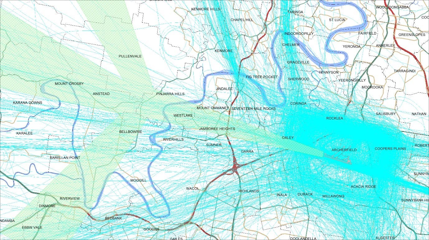
Example of current flight tracks at Archerfield Airport are shown with blue lines, new GNSS arrival flight path (as of 26 May 2016) shown in green (click here for larger image).
When will the changes happen?
The arrival flight path will be available for suitably equipped operators from 26 May 2016.
How many aircraft use this flight path?
The flight path is expected to be used, on average, for 15 flights a day.
Will GNSS flight paths be different?
Arrival flight paths using GNSS are aligned with the runway, whenever possible, to reduce the operating complexity for the pilot. CASA has decided that GNSS arrival flight paths not aligned with the runway (offset) may be used only when siting or obstacles permit no other option. An ‘offset’ arrival flight path cannot be established as a noise abatement measure.
-
Darwin arrivals and departures
In 2016 Airservices and Defence performed a regular review of the changes that were made in 2015 and identified some minor adjustments required to ensure the highest level of safety assurance is achieved and that aircraft are managed as efficiently as possible. These changes came into effect on 26 May 2016.
The changes either increased aircraft climb rates or modified the way aircraft turn when close to the airport in order provide more predictable tracking for aircraft.
Some residents in the southern suburbs of Palmerston may notice changes to non-jet aircraft taking off from Runway 11, with a greater spread of aircraft by approximately 1km due to the altitude turn requirement.
Howard Springs may also see a change in aircraft altitude and tracking, however, this is not expected to increase noise impacts.
Airservices expects the proposed changes are not likely to be noticeable by the community due to the high altitude of aircraft and distance from the airport. There will be no new residential areas exposed to aircraft noise.
Airservices will continue to inform residents on any updates as they come available and will work with Darwin Airport and the community to identify future noise improvement opportunities.
-
Gold Coast Airport
In accordance with the Civil Aviation Safety Authority (CASA) mandate and to ensure we continue to have the safest and most efficient air traffic management system possible, a series of changes are scheduled to occur at Gold Coast Airport from August 2016 to 2018 to maximise the benefits of satellite-based navigation systems, meeting the expectations of airspace users and the travelling public into the future.
Information on the flight path changes implemented on 18 August 2016 is available on our Aircraft Noise – Airports page under the Gold Coast Airport drop down menu.
What are the changes?
Links between flight paths to and from the north and east
The majority of commercial aircraft operating at Gold Coast Airport are travelling to and from destinations to the south. For this reason, the flight path network comprising of arrival and departure procedures are well established.
This is not the same for aircraft arriving to and from the north and east where there are ‘gaps’ between procedures off the coast. Aircraft are manually guided between these procedures by air traffic control which is an acceptable safe practice when traffic levels are low.
The ongoing growth in air traffic to and from the north and east now requires these flight paths to be linked up in order to ensure the highest levels of safety are maintained. Once this has occurred, pilots will be able to fly close to landing at the airport on autopilot without requiring the navigation assistance of air traffic control as currently occurs for aircraft travelling to and from the south.
Satellite-based procedures as the primary means of navigation for the majority of flights
There have been two broad forms of satellite-based navigation used by aircraft for landing: Required Navigation (RNAV), which provides horizontal guidance only, Required Navigation Performance – Authorisation Required (RNP-AR), known in Australia as ‘Smart Tracking’, which provides both horizontal and vertical guidance.
A new navigation system called Barometric Vertical Navigation (BARO VNAV) has recently been developed to assist pilots when landing. BARO VNAV uses satellite signals to position an aircraft horizontally and barometric pressure to control the vertical descent to the runway.
A Smart Tracking procedure will be established at the southern end of the airport which will be available for use by all suitably equipped aircraft. This will replace the existing Smart Tracking proprietary procedure which limits use to specified airlines and aircraft types. The Smart Tracking flight path will remain in its current location, offset to the east of the extended runway centreline.
For aircraft landing to the southern runway end, a BARO VNAV procedure will be established within the runway-aligned existing flight path corridor.
The Non-Directional Beacon (NDB) and VHF Omni-Directional Range (VOR) procedures involve tracking towards the ground-based navigation aids which are adjacent to, rather than in line with the runway. As the positions of the NDB and VOR on the ground are some 400 metres to the west of the runway, it is not possible for their new flight paths to be fully runway aligned.
Finalise consultation for the Instrument Landing System
The Instrument Landing System (ILS) proposal received Government approval in January 2016. It is anticipated the system and its new flight path will be available for use by mid to late-2017.
In the three months prior to the system becoming operational, Airservices and Gold Coast Airport will provide follow-up information to remind the community about the purpose of the system, its expected level of use and the anticipated noise impacts of aircraft using this flight path.
Revised noise abatement procedures
Noise abatement procedures are guidelines which aim to reduce the impact of aircraft noise on the community. They generally include procedures for preferred runway use and flight paths to reduce flights over residential areas.
Working with the Gold Coast Airport, respective airlines and the community Airservices intends to revise the Gold Coast Airport noise abatement procedures to create a baseline of expectation for aircraft to use alternate landing technology to the ILS and instead use satellite-based landing systems whenever possible as being preferred over ground-based navigation systems.
Finalising a draft change to the noise abatement procedures requires input from air traffic control to ensure the proposed wording is safe and practicable. The timing of any community discussion is yet to be determined.
When will the changes happen?
June 2016
Aircraft Navigation Modernisation Program for Gold Coast Airport presented to the community.August 2016
Runway 14 – Replace existing RNAV with runway aligned RNAV
Runway 14 – NDB/VOR straightened to five degree offset
Runway 32 – NDB/VOR straightened to five degree offsetMid 2017
Updated Noise Abatement ProceduresMid to late 2017
Runway 14 – Instrument Landing System commences operation
Runway 32 – New Smart Tracking flight path for aircraft arriving from the north and east
Runway 32 – Replace existing RNAV with BARO VNAVLate 2017
Runway 14 – Standard Arrival Routes (STAR) from north
Runway 14 – Standard Arrival Routes (STAR) from east (NZ)
Runway 14 – Standard Instrument Departures (SID) to north
Runway 32 – Standard Arrival Routes (STAR) from north
Runway 32 – Standard Arrival Routes (STAR) from east (NZ)Community Consultation
Airservices will present the Aircraft Navigation Modernisation Program for Gold Coast Airport to the community from June 2016 in conjunction with the airport’s established community forums (Community Aviation Consultation Group and Aircraft Noise Abatement Consultative Committee) and its proposed Draft 2017-2021 Master Plan consultation.
The community will be kept updated with the program’s key elements as they are progressively rolled out through to the end of 2017.
For more information
Contact the Noise Complaints and Information Service (NCIS) via:
- 1800 802 584 (freecall)
- our online form
- mail to Noise Complaints and Information Service, PO Box 211, Mascot NSW, 1460
- An interpreter service is also available on 131 450.
Related Information
-
Gold Coast navigation modernisation
A series of flight path changes came into effect at the Gold Coast Airport in August 2016. These changes are part of a nationwide Navigation Modernisation Program.
The changes are in response to the Civil Aviation Safety Authority (CASA) and International Civil Aviation Organisation (ICAO) requirements for increased runway alignment and for all aircraft operating under Instrument Flight Rules to be able to navigate using satellite-assisted means when flying in Australian airspace.
CASA and ICAO require Airservices to introduce these changes to ensure the highest levels of safety assurance is achieved in accordance with international practices and requirements.
What are the changes?
South of the Airport
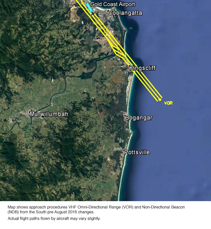
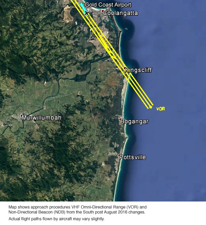
Change to the VHF Omni-Directional Range (VOR) and Non-Directional Beacon (NDB) procedures
This flight path was previously offset from runway alignment by 9 degrees. The change reduces this offset to 5 degrees and moves the flight path slightly to the west. Aircraft noise is expected to fall within the existing corridor. The VOR and NDB approach procedure is used infrequently as it does not employ the most current technology and is retained as a contingency approach.
(Above) Map shows approach procedures VHF Omni-directional Range (VOR) and NON-Directional Beacon (NDB) from the South pre August 2016 changes.
Actual flight paths flown by aircraft may vary slightly.(Above) Map shows approach procedures VHF Omni-Directional Range (VOR) and Non-Directional Beacon (NDB) from the South post August 2016 changes. Actual flight paths flown by aircraft may vary slightly.
North of the Airport
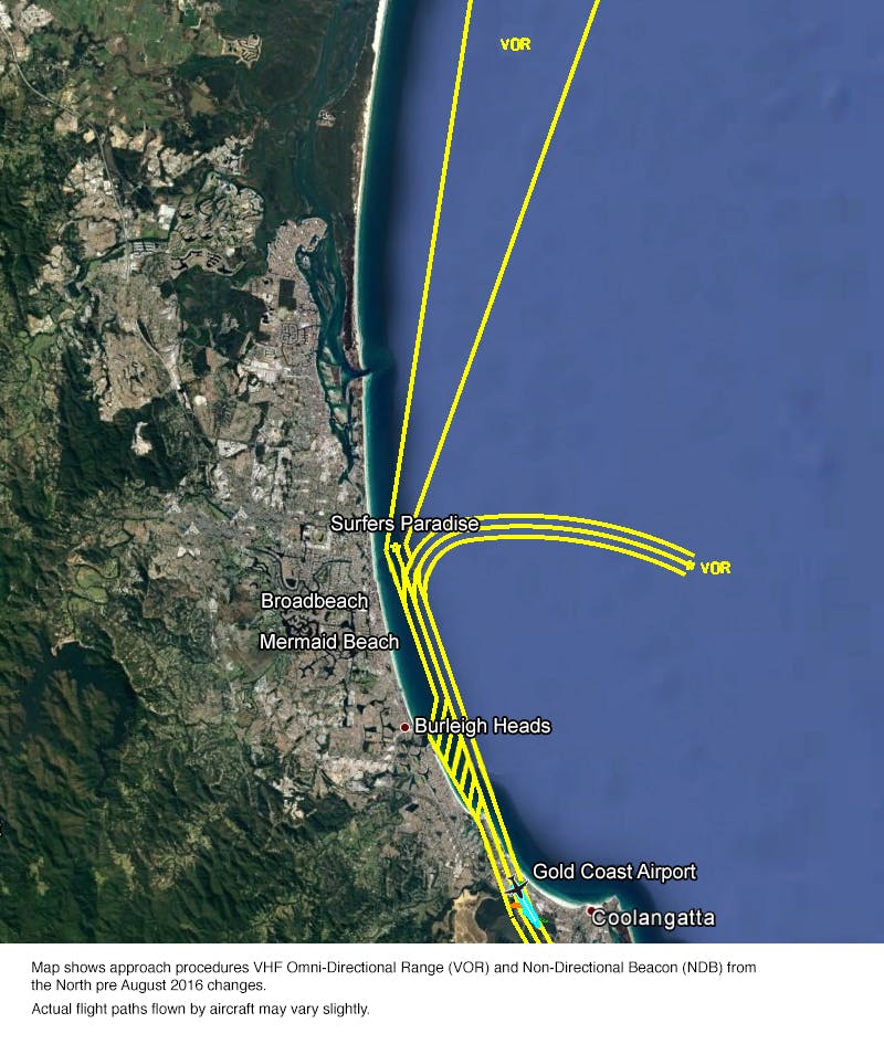
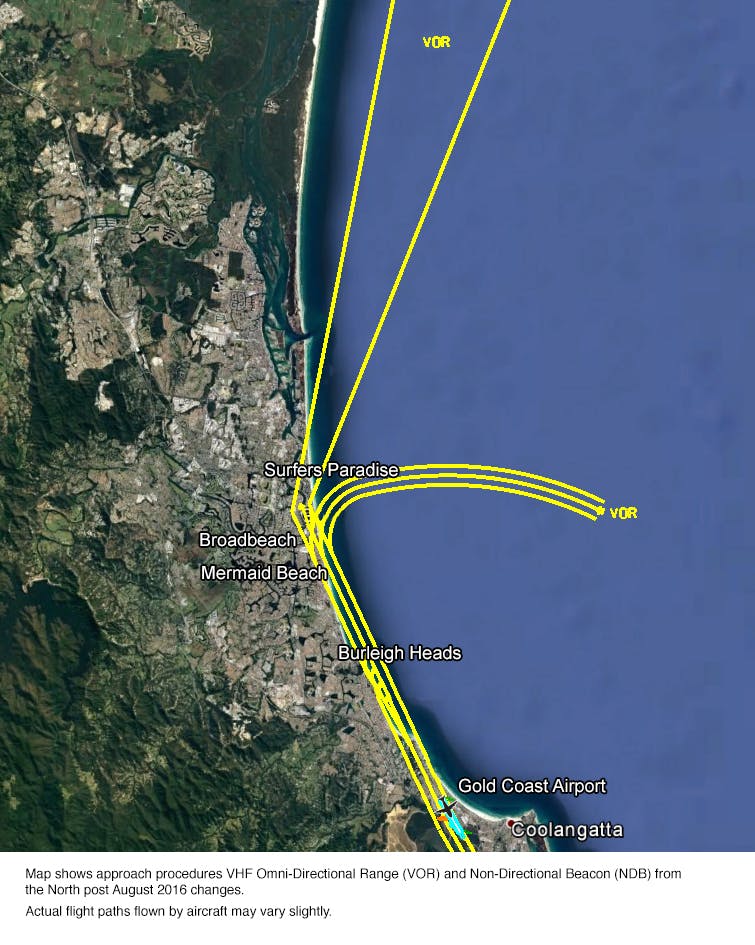
Change to the VHF Omni-Directional Range (VOR) and Non-Directional Beacon (NDB) procedures
This flight path was previously offset from runway alignment by 11 degrees. The change reduces this offset to 5 degrees. Aircraft will now cross the coast to fly over land between Surfers Paradise and Broadbeach, then continue south over Mermaid Beach before crossing the coast again and proceeding towards the airport over water. While tracking down the coast over water towards the airport, aircraft will now fly closer to land than previously. The VOR approach procedure is used infrequently as it does not employ the most current technology and is retained as a contingency approach.(Above) Map shows approach procedures VHF Omni-directional Range (VOR) and NON-Directional Beacon (NDB) from the North pre August 2016 changes.
Actual flight paths flown by aircraft may vary slightly.(Above) Map shows approach procedures VHF Omni-directional Range (VOR) and NON-Directional Beacon (NDB) from the North post August 2016 changes.
Actual flight paths flown by aircraft may vary slightly.Change to the area navigation RNAV approach
This flight path was previously offset from the runway by 12 degrees, producing a spread of aircraft traffic approaching the coast between Burleigh Heads and Currumbin to align with the runway. The new flight path will be runway aligned. Aircraft will now approach the coast at a more precise point at Palm Beach and fly closer to land than previously to align with the runway. Aircraft will remain over water until crossing the coast around Currumbin before landing.(Above) Map shows the approach procedure area navigation (RNAV) from the North pre August 2016 changes.
Actual flight paths flown by aircraft may vary slightly.(Above) Map shows the approach procedure area navigation (RNAV) from the North post August 2016 changes.
Actual flight paths flown by aircraft may vary slightly. -
Gold Coast southern departures reinstatement
Airservices proactively works with Gold Coast Airport and the community to minimise noise impacts where possible. To reduce the impact of aircraft noise on local residents and at the request of the community, Airservices trialled a change to a flight path for southern departures from Gold Coast Airport.
The trial flight path change commenced on 8 January 2015 for southern departures on Runway 14 and continued for 12 months, to cover normal seasonal patterns of runway use and allow the community the opportunity to provide feedback.
Airservices considers the trial did not achieve the intended noise reductions. The trial also unintentionally concentrated flights over Farrants Hill. Due to this, and in consideration of community feedback, Airservices has decided not to implement the trial flight path permanently. A process was undertaken to reinstate the Runway 14 departure flight path procedure which occurred on 23 June 2016.
Gold Coast Runway 14 southern departures trial (Banora Point Golf Course) outcome factsheet
Process undertaken
The process taken to reinstate the flight path included:
- The original APAGI RWY 14 Standard Instrument Departure (SID) was re-evaluated using the latest obstacle data and the current valid CASA Manual of Standards (MOS) 173 and ICAO criteria.
- CASA validation was approved and submitted to Airservices for review and endorsement.
- National Request for Change (NRCF) process commenced.
- NRFC process was completed and the procedure was submitted for publication as an AIP SUP and will be effective on the next AIRAC date.
- The next available AIRAC publishing date is 23 June 2016. Reinstatement will be effective and the new procedure available for use 23 June 2016.
International Civil Aviation Organisation (ICAO) recommends that an aeronautical change submitted to AIP becomes effective 56 days after publication to allow adequate time for the data to be entered into the air traffic control system and aircraft flight management systems.
Flight path design
Re-instating the pre-trial flight path required Airservices to update procedures in compliance with current design rules and limitations that were updated in 2015 (the pre-trial procedure was established in 2013). Due to this, there will be a small variation in the flight path that will be re-instated. The design rule requires a change in one Waypoint on the Standard Instrument Departure (SID). Whilst the waypoint locations are exactly the same, the waypoint closest to the runway had to be changed from a fly-by to a fly-over. This is due its close proximity to the runway which may cause the aircraft autopilot to turn well inside the waypoint and making the flight path corridor much larger than previously.
A small section of the flight path corridor from the Terranora Creek (near Pacific Motorway) to the southern end of the Banora Point Golf Course may be up to 100m wider than it was previously (image below). This change will have no noticeable difference in aircraft noise at ground level. It is also unlikely to be a visible change in aircraft tracking.
Related information
- Gold Coast runway 14 southern departures trial factsheet
- Gold Coast runway 14 southern departures trial environmental assessment
- Media release – Gold Coast Runway 14 southern departures trial (Banora Point Golf Course) outcome
- Gold Coast Runway 14 Southern departures trial (Banora Point Golf Course) outcome factsheet
- Gold Coast Runway 14 southern departures trial Post Implementation Review
-
Melbourne Smart Tracking
In November 2016 Airservices implemented a new international standard Smart Tracking procedure on Runway 16 to improve safety, noise and emission outcomes for Melbourne Airport.
What did not change?
Most aircraft movements around Melbourne Airport were unaffected.
When Runway 16 is in use for landing, aircraft generally arrive using the Instrument Landing System (ILS) which is runway aligned from approximately 15km to the north of the airport.
In good weather conditions, aircraft arriving from the west or south may also use a visual approach. This approach aligns with the runway closer to the airport at approximately 10km to the north. Using this visual approach also reduces fuel and emissions. Aircraft arriving on visual approaches navigate with visual reference resulting in a variation or spread of aircraft tracking as can be seen in blue in the image below.
What did change?
The new Smart Tracking approach procedures offer shorter routes than existing approaches. Airservices Smart Tracking procedures provide approved aircraft with improved guidance to the runway by using satellite navigation. Shorter approaches use less fuel and produce fewer emissions. Smart Tracking approaches are more accurate than the existing visual approaches and can appear more concentrated to some residents, however no new areas were exposed to aircraft noise as a direct result of implementing the flight path changes.
(Above) New Smart Tracking arrival flight path shown in white. Existing arrival flights tracks (which will not change) shown in blue.How many aircraft will use Smart Tracking?
On a busy day, approximately 280 jet aircraft arrive on Runway 16. Of these flights it is estimated that up to 30 (approximately 10% of arrivals to Runway 16) may use Smart Tracking to land. These numbers are estimates based on data from a 12 month period (1 July 2013 – 30 June 2014). Arrivals to Runway 16 are generally the highest during spring and summer due to the wind directions. Further information on runway selection.
Will there be more aircraft noise?
No new areas were exposed to aircraft noise as a direct result of the new Smart Tracking flight paths, as these areas were already currently overflown by aircraft (both arriving to Runway 16 and departing from Runway 34).
Residents in the Kalkallo, Craigieburn, Donnybrook, Mickleham and Oaklands Junction areas may visually notice a difference in where aircraft fly. While there may be a slight increase in the level of noise from these flights, it is not likely to be distinguishable due to the number of flights that already fly over these areas.
When did this change begin?
The updated flight paths was available for all suitably-equipped operators from 10 November 2016.
Related links
-
Townsville Smart Tracking
Aircraft have been using Smart Tracking flight paths in Townsville since 2011. On 10 November 2016 existing Smart Tracking flight paths to the north and south west of the airport were adjusted to meet the latest international requirements. These are set by the International Civil Aviation Organisation (ICAO).
The updated Smart Tracking flight paths for aircraft landing from the north onto Runway 19 are not noticeably different to the previous flight paths. There are slight changes to the Smart Tracking flight paths from the south onto Runway 01, and residents in the Kelso area may notice a difference. There may be a small increase in the number of flights using Smart Tracking. Whilst these areas were already overflown by departing and arriving aircraft, residents may notice that Qantas and Jetstar are flying more predictable paths. More airlines are expected to adopt the use of Smart Tracking in the future.


