
What do those letters mean?
Common acronyms we use
- Separation: keeping aircraft a minimum vertical or lateral distance apart, telling them when they can safely go ahead, go higher, lower or change direction.
- Flight information: advice and information such as weather, runway conditions and hazard warnings to ensure safe and efficient flight.
- Traffic information: advice and alerts to pilots about other aircraft positions, speeds and intended routes.
- Localiser (LOC) which is used for horizontal guidance
- Glideslope (GS) which is used for vertical guidance.
- preferred flight path and/or runway use
- restrictions on night-time movements
- approach procedures such as Continuous Descent Operations (CDO) and low power, low drag techniques
- modified flight path angles to adjust climb gradients
- restrictions on engine run-ups (a type of engine check) and/or use of ground equipment.
ATC
Air Traffic Control
Air traffic controllers keep aircraft at safe distances from each other in the air and on the ground, arranging them in an orderly flow for landing or take-off along defined flight paths. Controllers use specialised radar, communication and navigation systems and processes to allow aircraft to fly safely in our skies.
Air traffic controllers provide information to aircraft, pilots and crew, such as:
Different types of air traffic controllers manage aircraft through all phases of flight, from the departure gate before take-off to the arrival gate at the other end of the journey, and everything in between.
CACG
Community Aviation Consultation Group
Federally leased airports across the country facilitate CACG meetings to provide a structured way for community representatives to raise concerns, provide feedback and participate in discussions about environmental and aircraft movement impacts, airport developments and airport operations.
CDO
Continuous Descent Operations
An arrival procedure where an aircraft descends continuously using minimal engine thrust and low drag, which saves fuel and reduces noise.
CEP
Community Engagement Plan
A roadmap detailing how we will consult local communities regarding proposed changes to local flight paths or airspace
CER
Community Engagement Report
A summary of public consultation activities, community feedback, and recommendations regarding proposed changes to local airspace or flight paths
CES
Community Engagement Standard
Airservices' Community Engagement Standard provides a clearly defined process for engaging with the public on flight path and airspace changes of various scope, scale and complexity.
dB(A)
A-weighted decibels
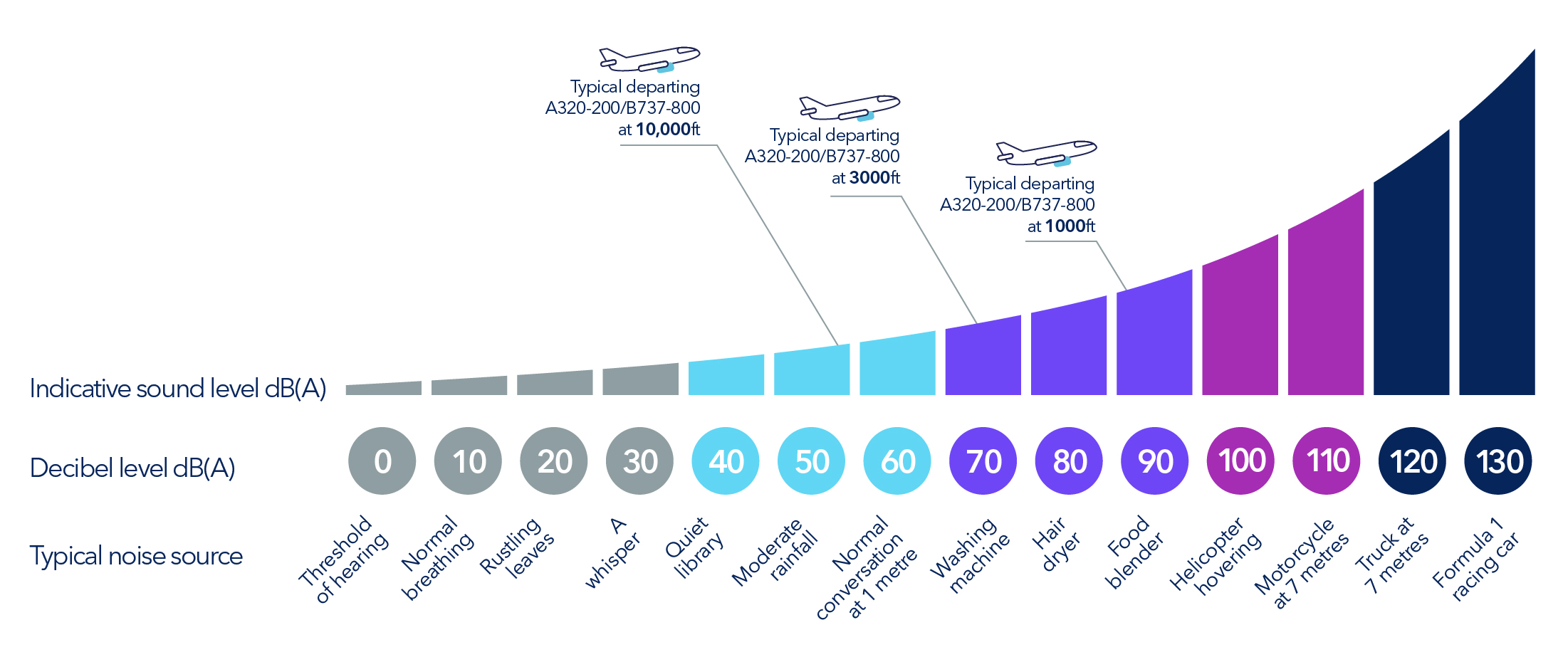
A measurement of sound pressure level that reflects how the human ear perceives loudness, adjusting for the ear’s sensitivity to different sound frequencies.
The image below shows some examples of common daily sounds and their corresponding A-weighted decibel reading.
EIA
Environmental Impact Assessment
A formal evaluation process used to identify, predict, and measure potential environmental and community changes—such as aircraft noise, emissions, and wildlife disruption—before modifying flight paths, airspace designs, or on-ground aviation infrastructure.
ILS
Instrument Landing System
An approach that can be conducted by all aircraft and is effectively an extension of the runway centreline, enabling the aircraft to fly a straight-in approach.
An ILS approach guides aircraft to the runway by two ground-based radio signals, one providing horizontal guidance and the other providing vertical navigational guidance.
These two radio signals are called:
When an aircraft intersects the LOC beam, it commences a straight-in approach towards the runway. When it intersects with the GS beam, the aircraft can safely descend.
ILS approaches are often used in poor weather or low visibility conditions.
NAP
Noise Abatement Procedure
Aircraft or airport procedures designed to reduce the impact of aircraft noise on the community.
NAPs can include:
Communities near airports may be sensitive to operations at different times of the day and night. This is reflected in some NAPs which apply at different times, including nominating the preferred runway use.
There are some limitations to the use of NAPs. NAPs are not regulations but rather procedures. There are circumstances where NAPs may not be used if they generate delay and congestion, as this can result in noise and emission impacts.
ATC or pilots may not be able to use them in certain situations, for example weather conditions or operational requirements.
NCIS
Noise Complaints and Information Service
Complaints and enquiries about aircraft noise and operations are managed through Airservices' NCIS.
The NCIS is the Australian aviation industry’s main interface on aircraft noise and related issues for the community.
RNP
Required Navigation Performance
This is a type of approach which uses a satellite-based system that allows aircraft to navigate along a precise path with on-board performance monitoring. It offers both lateral and vertical guidance, similar to ILS, but uses GPS and other on-board systems.
This type of approach allows for more precise and efficient flight paths compared to ILS.
RNP-AR
Required Navigation Performance – Authorisation Required
An advanced version of RNP which enables more complex manoeuvres, tighter and curved flight paths, allowing for more direct and efficient routes to the runway.
Only authorised aircraft flown by suitably qualified pilots may be assigned RNP-AR approaches by ATC.
Aircraft types typically authorised to use RNP-AR approaches include newer generation and generally more advanced aircraft such as the Boeing 737, Airbus A320, Airbus A380 and Boeing 787. However, aircraft operators may choose to retrofit this technology to other aircraft types.
RNP-AR approaches can benefit the environment by reducing aircraft noise, emissions and fuel usage, while at the same time helping to maintain reliable all-weather operations.
SID
Standard Instrument Departure
A published route aircraft use to safely guide them through the busy airspace surrounding airports, from departure to when they transition to the enroute (high level airspace) phase of flight.
Air Traffic Control (ATC) may vary a SID path for a particular aircraft in times of poor weather or when a slower aircraft is taking off prior to a faster aircraft.
STAR
Standard Terminal Arrival
A published route that aircraft follow to safely guide them through the busy airspace surrounding airports, similar to how roads guide us through suburbs.
STARs often have altitude and speed restrictions and generally start up to 100 nautical miles (NM) (185 kilometres) from the airport, and finish where the aircraft begins its final approach to land.