
Frequently Asked Questions
Aircraft noise
- preferred flight path and/or runway use
- restrictions on nighttime movements
- approach procedures such as Continuous Descent Operations (CDO) and low power, low drag techniques
- modified flight path angles to adjust climb gradients
- restrictions on engine run-ups (a type of engine check) and/or use of ground equipment.
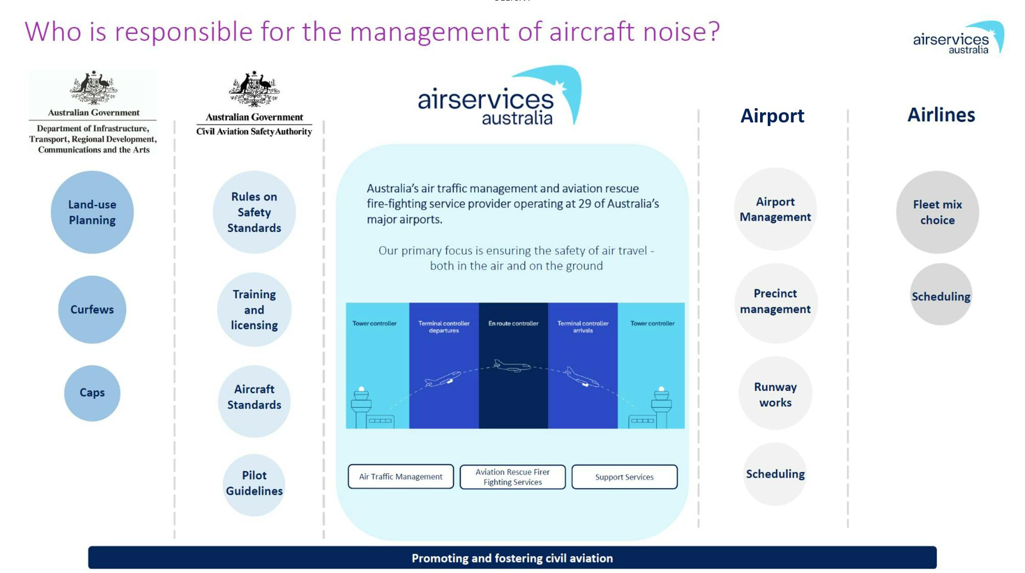
How are noise levels from aircraft operations measured and monitored?
Our Noise and Flight Path Monitoring System (NFPMS) collects noise and flight path data through noise monitoring terminals located around Brisbane, Cairns, Canberra, Gold Coast, Sydney, Melbourne, Essendon, Adelaide and Perth airports. These noise monitors operate 24-hours-a-day, seven-days-a-week, collecting data from aircraft operating to and from the airport.
Short-term noise monitors are deployed temporarily, often for a few months, to gather data on aircraft noise at specific locations.
They are used to investigate community concerns, validate noise models, measure the impact of flight path changes, or inform decisions about long-term monitoring locations.
Short-term noise monitoring complements the permanent monitoring by providing data in locations where long-term monitors are not feasible or necessary.
The data collected by these noise monitors is collated into reports and charts and is published on the Aircraft in your Neighbourhood website: https://aircraftnoise.airservicesaustralia.com/
Noise events recorded by the noise monitoring terminals are also available on the website: WebTrak
As an aircraft flies over a noise monitor, the noise level rises above the background noise level, peaks (usually within 10 seconds) and then slowly returns to the background level. This is a “noise event” and it lasts for around 20-40 seconds but varies depending on the height, type and loudness of the aircraft.
The sound that is detected by the noise monitor is measured on a logarithmic scale using decibels (dB), see image below.
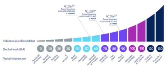
dB(A) stands for A-weighted decibels. This is a measurement of sound pressure level that reflects how the human ear perceives loudness, adjusting for the ear’s sensitivity to different sound frequencies. The image above shows some examples of common daily sounds and their corresponding decibel reading.
42dB(A) is generally used to represent the level at which aircraft noise becomes noticeable in rural areas.
50dB(A) is generally used to represent the level at which aircraft noise becomes noticeable in urban areas.
60dB(A) equates to the indoor design guide level of 50 dB(A) specified in the Australian Standard AS2021:2015 Acoustics – Aircraft noise intrusion – Building siting and construction, when sound absorption from a building is taken into consideration.
70dB(A) is considered to be the outdoor sound level below which there should be no difficulty hearing radio, television or conversational speech in a typical room with windows open. This equates to the indoor design guide level of 60 dB(A) specified in the Australian Standard AS2021:2015 Acoustics – Aircraft noise intrusion – Building siting and construction, when sound absorption from a building is taken into consideration.
LAMax is a sound measurement that relates to the maximum noise level during a single noise event, e.g. aircraft movement. This is often used in our information materials to present the loudest aircraft movement likely to be experienced, based on the loudest aircraft type. It does not represent the likely noise level of all aircraft movements.
N-above contours like N70 and N60, show the number of noise events exceeding a certain dB(A) level (e.g. 70dB(A) or 60 dB(A)) within a specific time period. These contours cover a geographical area and are mapped using noise modelling.
Is aircraft noise regulated in Australia?
In Australia, aircraft noise standards apply before an aircraft is permitted to operate, rather than in the course of its day-to-day flying activities.
Before an aircraft begins operating in Australia it is required to meet international noise standards that specify the amount of noise that may be emitted by that type or model of aircraft. If an aircraft does not pass the certification process, it may not fly in Australia. However, once an aircraft passes this certification process, there is no legislation or regulation that enables any agency, including Airservices, to police noise levels.
There is no regulated maximum noise level for aircraft flying over residential areas. Without any maximum level set out in legislation or regulation, there is no objective measure to determine whether any aircraft flying in Australia is “too noisy”, or whether the combined load of aircraft experienced by a community is “too much” noise.
Do all airports have curfews?
An airport curfew is a legislated restriction on aircraft operations (at federally leased airports) during a specified time period. Adelaide, Essendon, Gold Coast and Sydney airports are the only airports in Australia that have curfews. These curfews apply between 11pm and 6am. Airservices does not have the power to implement curfews. Airport curfews are legally enforceable and regulated by the Department of Infrastructure, Transport, Regional Development, Communications, Sport and the Arts, who can make a determination of a curfew violation and prosecute an airline or aircraft operator for breaching a curfew.
Are there ways to reduce noise from aircraft operations?
Noise Abatement Procedures (NAPs) are aircraft or airport procedures designed to reduce the impact of aircraft noise on the community. NAPs can include:
Communities near airports may be sensitive to operations at different times of the day and night. This is reflected in some NAPs which apply at different times, including nominating the preferred runway use.
There are some limitations to the use of NAPs. NAPs are not regulations but rather procedures. There are circumstances where NAPs may not be used if they generate delay and congestion, as this can result in noise and emission impacts.
ATC or pilots may not be able to use them in certain situations, for example weather conditions or operational requirements.
Flight paths and runways
- adverse weather
- obstacles on the runway
- pilot decision
- ATC instruction training.
What are flight paths?
Flight paths are pre-determined, three-dimensional corridors where aircraft fly most of the time. Flight paths can be several kilometres wide, rather than the fine, single lines depicted on maps. Aircraft may fly differently within flight paths for various reasons, such as aircraft performance, and the types of navigation systems on board the aircraft. Aircraft may need to deviate from flight paths for a range of reasons, including weather and operational requirements.
A Standard Instrument Departure (SID) is a published route aircraft use to safely guide them through the busy airspace surrounding airports, from departure to when they transition to the enroute (high level airspace) phase of flight. Air Traffic Control (ATC) may vary a SID path for a particular aircraft in times of poor weather or when a slower aircraft is taking off prior to a faster aircraft.
A Standard Terminal Arrival (STAR) is a published route that aircraft follow to safely guide them through the busy airspace surrounding airports, similar to how roads guide us through suburbs. STARs often have altitude and speed restrictions and generally start up to 100 nautical miles (NM) (185 kilometres) from the airport, and finish where the aircraft begins its final approach to land.
What are the different types of landing approaches?
An Instrument Landing System (ILS) can be conducted by all aircraft and is effectively an extension of the runway centreline, enabling the aircraft to fly a straight-in approach. An ILS approach guides aircraft to the runway by two ground-based radio signals, one providing horizontal guidance and the other providing vertical navigational guidance. These two radio signals are called: Localiser (LOC) that is used for horizontal guidance Glideslope (GS) that is used for vertical guidance. When an aircraft intersects the LOC beam, it commences a straight-in approach towards the runway. When it intersects with the GS beam, the aircraft can safely descend. ILS approaches are often used in poor weather or low visibility conditions.
Required Navigation Performance (RNP) uses a satellite-based system that allows aircraft to navigate along a precise path with on-board performance monitoring. It offers both lateral and vertical guidance, similar to ILS, but uses GPS and other on-board systems. This type of approach allows for more precise and efficient flight paths compared to ILS.
A Required Navigation Performance - Authorisation Required (RNP-AR) is an advanced version of RNP which enables more complex maneuvers, tighter and curved flight paths, allowing for more direct and efficient routes to the runway. Only authorised aircraft flown by suitably qualified pilots may be assigned RNP-AR approaches by ATC. Aircraft types typically authorised to use RNP-AR approaches include newer generation and generally more advanced aircraft such as the Boeing 737, Airbus A320, Airbus A380 and Boeing 787. However, aircraft operators may choose to retrofit this technology to other aircraft types. RNP-AR approaches can benefit the environment by reducing aircraft noise, emissions and fuel usage, while at the same time helping to maintain reliable all-weather operations.
A visual approach is an approach to a runway where the pilot uses visual cues, often major landmarks, highways or bodies of water. The pilot must be able to see the ground and follow ATC instructions at all times. Visual approaches provide flexibility and are typically shorter flight paths to the runway, often preferred by local pilots but not always available due to bad weather or other aircraft being in the vicinity.
A missed approach, also known as a go-around, is a standard procedure in aviation where an aircraft aborts its landing and climbs away from the runway to either hold, divert or reposition for another landing attempt. Reasons for a missed approach may include:
Other procedures
Continuous Descent Operations (CDO) is an arrival procedure where an aircraft descends continuously using minimal engine thrust and low drag, which saves fuel and reduces noise.
Holding patterns are most often an oval shaped course, flown by aircraft awaiting clearance to land. Aircraft may need to fly in a holding pattern due to unfavourable weather or traffic congestion. The size of a holding pattern varies depending on aircraft altitude and speed, as well as the wind direction and speed.
The enroute network is the higher-altitude airspace that connects departure and arrival procedures between airports. SIDs and STARs connect to the enroute network through precisely located waypoints.
A waypoint is a geographical location defined by specific coordinates, used as a reference point for aircraft navigation. They typically take the form of a five-letter capitalised word; for example, SALLY, WACKO, KADOM. They are simple and distinct so they can be easily communicated between ATC and pilots.
How do runways operate?
Runway naming: runways are numbered according to compass directions with 360 degrees representing north (referred to as 36 in runway naming conventions). For example, a runway that runs from due east to due west would be called Runway 09/27, as east is at 90 degrees on a compass and west is at 270 degrees.
Runway selection and use: ATC decides which runways to use based on the weather conditions, wind direction and speed and how busy the airport is. Aircraft need to take off and land into the wind, or with minimal tail wind. The existing and forecast wind direction dictates which runway is in use at any given time. When ATC changes the runway mode, the flight paths for arriving and departing aircraft also change and this can happen at short notice. This is why communities may see and hear different aircraft patterns overhead at different times.
Wind blowing across the runway is called a cross wind. Aircraft can take off or land generally with only a low cross wind, usually up to a strength of about 15 knots (28km per hour). If the wind is stronger than that, aircraft may be delayed, need to use another runway or divert to an alternative airport.
Wind data used by ATC and the Bureau of Meteorology (BoM) may differ slightly. BoM uses a single instrument located on the airfield and reports at scheduled times throughout the day. ATC on the other hand, use multiple instruments positioned at the end of each runway, providing minute-by-minute updates.
Navigation
How do pilots navigate?
Aircraft that fly using landmarks for visual cues and radio communication to track their course use Visual Flight Rules (VFR). This type of navigation usually applies to light aircraft and helicopters.
Aircraft that fly using instrumentation and communication with ATC to track their course use Instrument Flight Rules (IFR).
How low can aircraft fly?
The Civil Aviation Safety Authority (CASA) has regulations for how low aircraft can fly. These regulations require pilots fly no lower than 1000ft (305m) above the ground in built up urban areas or 500ft (152m) in non-residential areas, unless they are in the process of landing or taking off. Other exceptions include if they are performing a missed approach procedure, practising emergency procedures or undertaking circuit training. Helicopters may fly below 1000ft in specified areas, provided they do so safely and in accordance with CASA regulations.
What are the different types and classifications of airspace?
There are two major types of airspace: controlled and uncontrolled.
Controlled airspace in Australia is actively monitored and managed by air traffic controllers. To enter controlled airspace, a pilot must first gain clearance from an air traffic controller.
Uncontrolled airspace has no supervision by air traffic controllers, so no clearance is required to operate in this airspace. These aircraft have access to information provided by ATC, including updates on weather and other traffic in the area. The large majority of light aircraft and helicopters operate outside or underneath controlled airspace.
The image below represents the classes of airspace in Australia and how they connect and overlap. The level of service an aircraft receives from air traffic control and the classes of airspace in which it can fly are determined by whether it is operating under VFR or IFR.
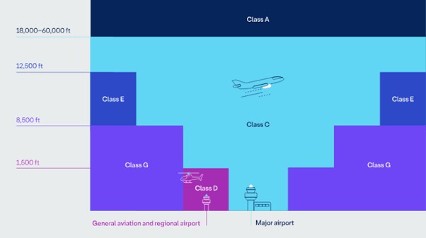
Class A: This high-level enroute controlled airspace is used predominately by commercial and passenger jets. Only IFR flights are permitted and they require clearance from ATC.
Class C: This is controlled airspace surrounding major airports. Both IFR and VFR flights are permitted and must communicate with ATC.
Class D: This is the controlled airspace that surrounds general aviation and regional airports equipped with a control tower. All flights require ATC clearance.
Class E: This mid-level enroute controlled airspace is open to both IFR and VFR aircraft. IFR flights are required to communicate with ATC and must request ATC clearance.
Class G: This airspace is uncontrolled. Both IFR and VFR aircraft are permitted and neither require ATC clearance but must remain clear of controlled airspace.
*Note: At airports where an air traffic control tower is present, the class of airspace may change subject to the time of day; for example, some towers are only staffed during the day so they will operate as Class D during the day and Class G when the tower is closed.
To operate in restricted airspace, aircraft must have specific permission. Examples of restricted airspace include airspace around military areas, an air show or other large public event. Restricted airspace may also be imposed by police for safety or security reasons near bushfires or major crime scenes. Some areas of restricted airspace do not permit any aircraft to operate.
How close can aircraft fly to each other?
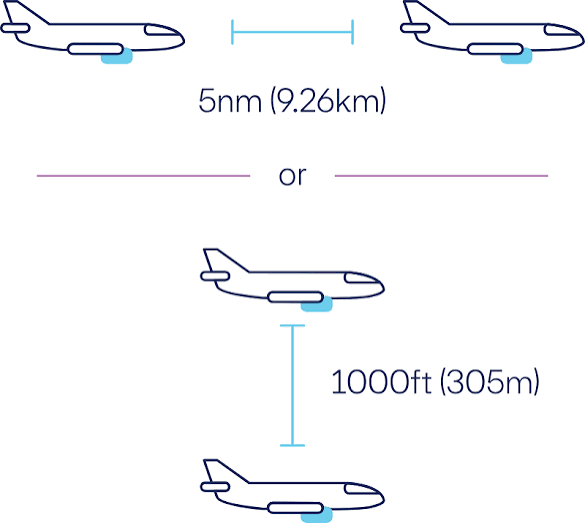
Separation standards refer to the minimum distance aircraft must be apart in controlled airspace and at airports with an operational control tower. Different separation standards apply to aircraft operating under IFR (most large passenger aircraft) or VFR (most light aircraft and helicopters). Air traffic controllers must keep aircraft separated vertically and horizontally. In Australia, IFR aircraft in controlled enroute airspace up to 29,000ft (8800m) must be separated by 1000ft (305m) vertically unless they are separated horizontally.
Aircraft in controlled enroute airspace at the same altitude must be horizontally separated by a minimum of 5 nautical miles (nm), see image below. Vertical separation requirements increase to 2000ft when the aircraft altitude is above 29,000ft.
When the aircraft enters the ATC controlled airspace closer to the airport the minimum horizontal separation reduces without compromising safety as aircraft are being managed by ATC.
In the air, separation of VFR aircraft depends on where aircraft are flying. In the vicinity of capital city airports (controlled airspace), VFR and IFR aircraft are separated by similar horizontal standards as between two IFR aircraft. However, IFR and VFR flights may be separated vertically by a reduced standard of 500ft (152m) under certain circumstances. Outside controlled airspace, VFR aircraft operate under ‘alerted see and avoid’ principles, whereby pilots rely on a mix of visual scanning, radio broadcasts, air traffic control flight information and various ‘give way’ rules of the air to remain clear of other aircraft.
Do emergency services aircraft behave differently to other aircraft?
Emergency services operations use both fixed-wing aircraft and helicopters for: aeromedical services (air ambulance, medical evacuations, patient transport and urgent organ transport, e.g. the Royal Flying Doctor Service) firefighting response and support search and rescue missions police activities.
Emergency services operations are sometimes more noticeable to the community because they often fly in areas outside regular flight paths and perform unusual activities like repetitive circling and low-level flying.
Emergency services operations are usually unplanned and can occur at any time of the day or night. Because of their urgency, emergency services operations may take priority over other aircraft and may use a different runway than those used by regular operations. Aircraft nearby may be asked to hold their position by circling or hovering in the air to allow the emergency services aircraft to quickly land or depart. Aircraft will generally be no lower than 1000ft (305m) over built-up areas and 500ft (152m) over other areas, except for take-off or landing. However, emergency services aircraft are typically approved by CASA to operate at lower altitudes in certain emergency situations.
What is circuit training?
Circuit training is a key part of pilot training, focused on take-offs and landings. It involves flying a looped path around the airport—approaching the runway, briefly touching down, and then taking off again. Circuit training is undertaken at most airports, particularly regional and general aviation aerodromes. The track of a circuit, how it is flown and its location is determined by CASA. Because of proximity to airports, this may mean aircraft fly over residential areas during training.
Restrictions on circuit training operational hours: There are no regulated hours for circuit training. Each airport sets its own schedule based on: pilot training demand the number and time of other scheduled flights into and out of the aerodrome runway capacity and configuration availability of ATC services the type of navigational equipment available at the aerodrome. Training during both day and night is important for developing pilot competencies and experience using different types of navigational aids, however many airports restrict circuit training at night and in the early morning. Individual airports publish this information on their websites in relation to circuit training.