2018 Changes
This page provides a summary of the flight path and airspace changes we implemented in 2018.
To learn more about each change click on the title of the change below or access the document library on the right.
For questions about the below changes and/or matters relating to current aircraft operations, please contact our Noise Complaints and Information Service (NCIS).
To learn more about each change click on the title of the change below or access the document library on the right.
For questions about the below changes and/or matters relating to current aircraft operations, please contact our Noise Complaints and Information Service (NCIS).
This page provides a summary of the flight path and airspace changes we implemented in 2018.
-
Brisbane Airport Changes to the arrival flight path from the north to Runway 19
8 November 2018
Following consultation Airservices has implemented changes to the standard instrument arrival flight path to Brisbane Airport for aircraft arriving to Runway 19 from the north.
These changes are to ensure pilots can keep the aircraft in autopilot when descending to the airport from the north, and that tracking and speed are consistent for all aircraft as they approach the runway.
For more information please see the Fact Sheet – Brisbane Airport Implementation of Changes to Runway 19.
This page provides a summary of the flight path and airspace changes we implemented in 2018.
-
Brisbane Airport Helicopter and Light Aircraft Routes
31 October 2018
Airservices will implement standard flight path routes to and from Brisbane Airport for helicopters and light aircraft from 1 November 2018.
For a summary of the feedback received on this change please see Helicopter and Light Aircraft Routes Summary of Feedback.
13 September 2018
Airservices will implement standard flight path routes to and from Brisbane Airport for helicopters and light aircraft from 1 November 2018. This change formalises the routes by publishing them in aeronautical documents. This allows pilots to lodge flight plans for flights on these routes and improves how that information is displayed usingContinue reading
31 October 2018
Airservices will implement standard flight path routes to and from Brisbane Airport for helicopters and light aircraft from 1 November 2018.
For a summary of the feedback received on this change please see Helicopter and Light Aircraft Routes Summary of Feedback.
13 September 2018
Airservices will implement standard flight path routes to and from Brisbane Airport for helicopters and light aircraft from 1 November 2018. This change formalises the routes by publishing them in aeronautical documents. This allows pilots to lodge flight plans for flights on these routes and improves how that information is displayed using the air traffic control radar system, particularly for departing light aircraft. For more information read our Fact Sheet.
This page provides a summary of the flight path and airspace changes we implemented in 2018.
-
Gold Coast Airport Smart Tracking Update Runway 32
31 January 2019
Following community consultation between 19 October 2018 and 29 November 2018, Airservices will implement Smart Tracking for Runway 32 from 28 March 2019.
For more information please see the Gold Coast Airport Smart Tracking Update – Runway 32 Fact Sheet.
21 December 2018
Airservices consulted the community about a proposal to implement a flight path change for the current Smart Tracking flight path for Runway 32 at the Gold Coast Airport. Consultation occurred between 19 October 2018 and 29 November 2018.
For a summary of feedback received on this proposed change, please see Summary of CommunityContinue reading
31 January 2019
Following community consultation between 19 October 2018 and 29 November 2018, Airservices will implement Smart Tracking for Runway 32 from 28 March 2019.
For more information please see the Gold Coast Airport Smart Tracking Update – Runway 32 Fact Sheet.
21 December 2018
Airservices consulted the community about a proposal to implement a flight path change for the current Smart Tracking flight path for Runway 32 at the Gold Coast Airport. Consultation occurred between 19 October 2018 and 29 November 2018.
For a summary of feedback received on this proposed change, please see Summary of Community Feedback – Smart Tracking Runway 32.
19 October 2018
Airservices is implementing improvements in satellite assisted aircraft navigation as part of a national initiative to provide additional safety, landing predictability, fuel and emissions benefits to airlines. This program is known as Smart Tracking. Airservices is proposing to update the Smart Tracking approach procedures at Gold Coast Airport for aircraft landing on Runway 32 from the south.
For more information please see the Gold Coast Airport Smart Tracking Update – Runway 32 Fact Sheet.
This page provides a summary of the flight path and airspace changes we implemented in 2018.
-
Maryborough Airport Proposed Changes to Runway 17 GPS Approach Flight Path
18 December 2018
Airservices conducted community consultation on the proposed changes to the satellite navigation (GPS) approach flight path for aircraft landing from the north onto Runway 17 at Maryborough Airport between 29 October 2018 -13 December 2018.
No community feedback was received on the proposed change.
The proposal will proceed to implementation on 28 February 2019.
Please refer to the fact sheet Maryborough Airport Proposed Changes to Runway 17 for more information on this change.
29 October 2018
Airservices is proposing changes to the satellite navigation (GPS) approach flight path for aircraft landing from the north onto Runway 17Continue reading
18 December 2018
Airservices conducted community consultation on the proposed changes to the satellite navigation (GPS) approach flight path for aircraft landing from the north onto Runway 17 at Maryborough Airport between 29 October 2018 -13 December 2018.
No community feedback was received on the proposed change.
The proposal will proceed to implementation on 28 February 2019.
Please refer to the fact sheet Maryborough Airport Proposed Changes to Runway 17 for more information on this change.
29 October 2018
Airservices is proposing changes to the satellite navigation (GPS) approach flight path for aircraft landing from the north onto Runway 17 at Maryborough Airport. Residents in the Howard, Torbanlea, Burgowan, Walligan, Susan River, Toogoom and Takura areas may notice a change in aircraft tracking.
For more information please see the Maryborough Airport Proposed Changes to Runway 17 factsheet.
This page provides a summary of the flight path and airspace changes we implemented in 2018.
-
Melbourne Airport Smart Path
December 2018
Airservices will implement Smart Path Runway 34 (South) from 8 December 2018.
For a summary of the feedback received on this change please see Summary of Community Feedback – Smart Path for Runway 34 (South) under Downloads.
Previous Updates
October 2018
Airservices is introducing Smart Path technology at Melbourne Airport to improve safety and predictability for aircraft landing in poor weather and low visibility.
Smart Path is a Global Navigation Satellite System (GNSS) based precision approach and landing system. Since 2017, this has been available for all runways at Melbourne Airport except to Runway 34 from the south.
Airservices is now proposing to install this technology to Runway 34.
For more information please see the Melbourne Airport Smart Path for Runway 34 (South) Fact Sheet under Downloads.
For more information and to provide feedback:
Contact Airservices Noise Complaints and Information Service:
- 1800 802 584 (free call);
- 131 450 (interpreter service) or
- online at https://complaints.bksv.com/asa
Please provide feedback by 21 November 2018.
May 2018
Airservices will be introducing changes to the airspace surrounding Melbourne Airport on 8 November 2018. The airspace changes are required to meet new regulations to safely manage incoming flights on approach to Melbourne Airport. There will be no changes to the current flight paths. The change requires aircraft to fly slightly lower (500ft) during a small section of their final approach. Environmental assessments indicate there will be no discernible increase in aircraft noise on the ground.
Lowering of airspace south of the Airport
Airservices is introducing Smart Path technology at Melbourne Airport to improve safety and predictability for aircraft.
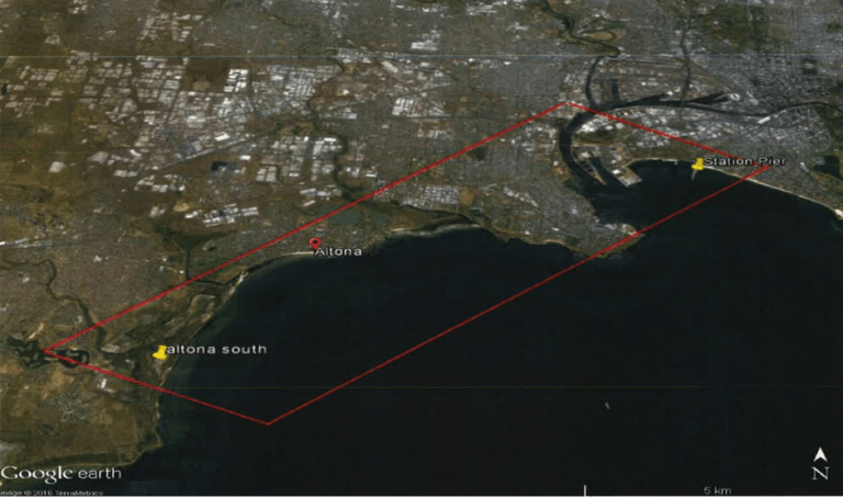
Airservices has requested that the Civil Aviation Safety Authority (CASA) approve the lowering of controlled airspace at the edge of Port Phillip Bay between Altona South and Station Pier. This will facilitate the introduction of a precision approach using Ground Based Augmentation System (Smart Path) technology, into Melbourne Airport from the south.
What is Smart Path technology?
Smart Path technology is a Global Navigation Satellite System (GNSS) based precision approach and landing system. This landing system was installed for other approaches at Melbourne Airport in 2017, to provide Australian and international airlines with access to the technical and operational advantages from this form of precision approach.
This technology provides a precision approach with vertical guidance, which results in significant improvements in safety and predictability for landing in poor weather and navigating terrain. Further information on this technology can be found on the Airservices website at http://www.airservicesaustralia.com/projects/ground-based-augmentation-system-gbas/
What is going to change?
In order to introduce Smart Path technology to the approach route south of Melbourne Airport, the controlled airspace at the edge of Port Phillip Bay between Altona South and Station Pier, will require lowing by 500ft.
Light general aviation aircraft currently use the airspace between Altona South and Station Pier to track along the coast. They currently fly between 500ft and 2500ft. The lowering of airspace along this route will require the aircraft to fly lower – between 500ft and 2000ft.
The proposed airspace change will not result in any changes to flight paths, however more light aircraft may be a lower altitudes. In 2017 12% of the total number of light aircraft that fly along this route are between 2000ft and 2500ft, therefore residents may notice that these aircraft will be flying lower as a result of the airspace change.
Will there be any change to aircraft noise?
Residents are not expected to experience noticeable changes to noise levels. For the proposed altitude change of 500ft an increase in noise level of approximately 2 dB(A) can be expected.
When will this change start?
Following approval from CASA, it is anticipated that the changes will be implemented in November 2018.
Where can I get more information or provide feedback on the change?
More information on Airservices operations at Melbourne Airport can be found at http://www.airservicesaustralia.com/aircraftnoise/Melbourne/
To contact Airservices regarding this change call Airservices Noise Complaints and Information Service: 1800 802 584 (free call), an interpreter service is also available on 131 450 or visit the website at: https://complaints-au.emsbk.com/asa5
Figure 1: Area controlled airspace to be lowered. Click here for larger image.
Smart Path for Runway 34
Airservices is introducing Smart Path technology at Melbourne Airport to improve safety and predictability for aircraft.
In 2017 Airservices installed the satellite based navigation precision landing system, known as Smart Path technology to a number of approach procedures at Melbourne Airport. This technology provide airlines with safer guidance to the runway.
What is Smart Path technology?
Smart Path is a Global Navigation Satellite System (GNSS) which provides Australian and international airlines with access to technical and operational advantages of this form of precision approach.
This technology provides a precision approach with vertical guidance, which results in significant improvements in safety and predictability for landing in poor weather and navigating terrain. Further information on this technology can be found on the Airservices website at http://www.airservicesaustralia.com/projects/ground-based-augmentation-system-gbas/
What Is Going To Change?
Following the implementation of Smart Path technology to other approaches at Melbourne Airport in 2017, Airservices is now proposing to provide this technology to Runway 34.
Implementation of Smart Path to Runway 34 provides a vertically guided precision approach ensuring that aircraft using this technology will be on a vertically and laterally guided path, to improve landing capability in poor weather when there are northerly winds.
To comply with international design standards Airservices must ensure that the final approach is correctly intercepted by aircraft. To enable this, aircraft may be up to 500ft lower between 25km and 15km from the runway landing point. The reduction in height will vary according to how the flight management computers in the aircraft manage the length of flat segment required prior to landing. There are no lateral changes to the existing flight paths.
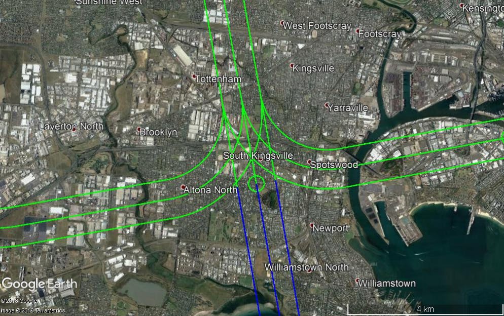
Aircraft using Smart Path to land at Melbourne Airport from the south onto Runway 34 will be on existing flight paths as shown in Figure 1.
Will There Be Any Change In Aircraft Noise?
It is anticipated that an average of approximately 30 aircraft per day and maximum of approximately 130 on any given day, arriving to Melbourne Airport from the south to Runway 34, will use Smart Path navigation. Based on current fleet capability this is approximately 40% of jets using the existing flight path, as not all aircraft are equipped to use Smart Path.
Aircraft using Smart Path technology to land at Melbourne Airport from the south onto Runway 34 will be on existing flight paths, however Aircraft may be up to 500ft lower from the existing altitude of 3000ft to the proposed level of 2500ft.
Residents in Laverton, Altona, Brooklyn, Yarraville, Port Melbourne, Kingsville, South Kingsville, Tottenham, West Footscray, Altona Nth, Newport and Spotswood areas may notice that some aircraft, particularly larger aircraft may be up to 500ft lower. Noise modelling indicates that some residents may experience an increase in single noise event levels of between 0.4 – 1.6dB(A), however it is anticipated that this level of increase will not be perceptible.
When will this change start?
Following approval from CASA, it is anticipated that the changes will be implemented in November 2018.
Where can I get more information or provide feedback on the change?
More information on Airservices operations at Melbourne Airport can be found at http://www.airservicesaustralia.com/aircraftnoise/Melbourne/
To contact Airservices regarding this change call Airservices Noise Complaints and Information Service: 1800 802 584 (free call), an interpreter service is also available on 131 450 or visit the website at: https://complaints-au.emsbk.com/asa5
Figure 1: Existing flight paths to Runway 34
Aircraft within the green and blue corridors may be up to 500ft lower (arriving Smart Path aircraft will be between 3,000ft and 2,500ft in the corridors shown).
Downloads
Summary of Community Feedback
- Summary of Community Feedback – Smart Path for Runway 34 (South)
- Summary of Community Feedback – Lowering of airspace
Fact Sheets
This page provides a summary of the flight path and airspace changes we implemented in 2018.
-
Moorabbin Airport Non Directional Beacon Minimum Holding Altitude Change
Moorabbin Airport Non Directional Beacon Minimum Holding Altitude Change
At the end of April 2018, Airservices communicated that the proposed change to the Non Directional Beacon (NBD) minimum holding altitude at Moorabbin airport was under review.
Following this review, inclusive of the stakeholder feedback received to date, Airservices would now like to advise that at this time there is no planned alteration to the NDB minimum holding altitude at Moorabbin airport and the proposed change to the NDB minimum holding altitude will not proceed.
Airservices is committed to providing information to stakeholders and the community on significant changes that mayContinue reading
Moorabbin Airport Non Directional Beacon Minimum Holding Altitude Change
At the end of April 2018, Airservices communicated that the proposed change to the Non Directional Beacon (NBD) minimum holding altitude at Moorabbin airport was under review.
Following this review, inclusive of the stakeholder feedback received to date, Airservices would now like to advise that at this time there is no planned alteration to the NDB minimum holding altitude at Moorabbin airport and the proposed change to the NDB minimum holding altitude will not proceed.
Airservices is committed to providing information to stakeholders and the community on significant changes that may affect them, and to incorporating stakeholder feedback into our planning, decision-making and implementation processes.
For any further enquiries please contact stakeholder@airservicesaustralia.com
This page provides a summary of the flight path and airspace changes we implemented in 2018.

Documents
-
 Brisbane Airport Changes to the arrival flight path from the north to Runway 19
-
Brisbane Airport Helicopter and Light Aircraft Routes
-
Gold Coast Airport Smart Tracking Update Runway 32
-
Maryborough Airport Proposed Changes
-
Melbourne Airport Smart Path
-
 18-0011-FAC-Melbourne-Airport-Smart-Path_Lowering_airspace.pdf (274 KB) (pdf)
-
2018_Melbourne_Smart_Path_Fig1.2.png (805 KB) (png)
-
2018_Melbourne_Smart_Path_Fig1.png (537 KB) (png)
-
Melbourne-Airport-Smart-Path-FAQ_Runway-34.pdf (301 KB) (pdf)
-
Melbourne-Airport-Smart-Path-FAQ_Runway-34-south.pdf (201 KB) (pdf)
-
MLB_Summary-of-Feedback-Smart-Path-for-Runway-34-south.pdf (184 KB) (pdf)
-
Summary-of-Community-Feedback_Lowering-of-airspace.pdf (183 KB) (pdf)
-