2017 Changes

This page provides a summary of the flight path and airspace changes we implemented in 2017.

This page provides a summary of the flight path and airspace changes we implemented in 2017.

To learn more about each change click on the title of the change below or access the document library on the right.

For questions about the below changes and/or matters relating to current aircraft operations, please contact our Noise Complaints and Information Service (NCIS).

This page provides a summary of the flight path and airspace changes we implemented in 2017.

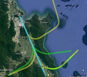
  • Cairns Smart Tracking

    On 22 June 2017 Airservices is updating the Smart Tracking procedures for aircraft landing at Cairns Airport. This is part of a nation-wide program to provide additional aircraft with safety, landing predictability, fuel and emissions benefits. This also provides opportunities to look for ways to improve noise outcomes.

    Smart Tracking flight paths have been updated to follow existing flight paths as closely as possible and most changes are over water.

    The image below shows that the Smart Tracking flight path from the south west to land at the airport from the south has moved from west of Aloomba (in green) to east of Aloomba (in yellow). Noise levels are expected to be similar to those from existing arriving flights but the community of Aloomba may notice a change in where aircraft are tracking.

    The Smart Tracking flight path from the north east to land at the airport from the south keeps aircraft just to the west of Fitzroy Island National Park as shown in the image below. The Fitzroy Island community may notice arriving aircraft west of the Island. This area is currently overflown by departures.

    (Above) In green – flight path corridors prior to 22 June 2017 that will be removed. In yellow – new flight path corridors after 22 June 2017. In blue – flight path corridors that will not change.

  • Canberra Smart Tracking

    25 May 2017

    Canberra has a modern aircraft fleet and in response to public demand the number of flights is forecast to grow by over 30 per cent by 2020 (compared to 2012 levels). Smart Tracking aircraft will be the cornerstone technology to cater for this growth in a sustainable way.

    To enable a wider range of aircraft to use Smart Tracking at Canberra Airport, Airservices is implementing new international standard Smart Tracking procedures on Runway 17 and 35 to improve safety, noise and emissions outcomes for Canberra Airport.

    What is going to change?

    The updated Smart Tracking arrival flight paths closely replicate the existing Smart Tracking arrival flight paths, with minor changes occurring within existing flight path corridors.

    Residents may notice small changes to aircraft tracking however these changes are not expected to result in a noticeable difference in noise levels.

    When will the change begin?

    The updated flight paths will be available for all suitably-equipped operators from 25 May 2017.

    Will there be more aircraft noise?

    No new areas will be exposed to aircraft noise as a result of the updated Smart Tracking flight paths, as these areas are already overflown by aircraft. There should not be any noticeable difference in aircraft noise.

    Maps

    Canberra Runway 17

    Runway 17 – Smart Tracking arrival flight path from 25 May 2017 shown in yellow. Smart Tracking arrival flight path pre-25 May 2017 shown in green.

    Canberra Runway 35

    Runway 35 – Smart Tracking arrival flight path from 25 May 2017 shown in yellow. Smart Tracking arrival flight path pre-25 May 2017 shown in green.

    History of Smart Tracking at Canberra

    Smart Tracking was trialled at Canberra from 2006 by one airline and was made permanently available in February 2013. Seven tracks are used for aircraft arriving to Canberra Airport. Each track is within an existing flight path corridor and replicates those used in the trial.

    At the time of community engagement on the Smart Tracking proposals, Airservices produced the following information documents:

  • Mackay Airport Standard Arrivals and Departures

    August 2017

    Airservices is implementing standard arrival and departure routes at Mackay Airport to improve safety and the predictability at Mackay. These routes are expected to be used during periods of inclement weather and at night, during fine weather aircraft are expected to track as they do now.

    When these routes are in use residents may notice a greater consistency of where aircraft are tracking, particularly during poor weather or at night. When aircraft are departing to the north, the areas of Mt Pleasant and Glenella are expected to notice this consistency.

    More information can be found on our Fact Sheet.

  • Melbourne Airport Standard Arrivals and Departures

    Airservices will implement the following flight path changes at Melbourne Airport on 25 May 2017.

    Runway 09 Standard Terminal Arrival Route changes

    There will be changes to the Standard Terminal Arrival Route for aircraft arriving to Runway 09 from the west to allow implementation of the Ground Based Augmentation System (GBAS) at Melbourne Airport.

    This new satellite based navigation system with ground based augmentation provides increased likelihood of landing in poor weather and improved protection from terrain for the newer jet aircraft. GBAS provides similar benefits to an Instrument Landing System (ILS). An ILS is not installed on Runway 09.

    An additional benefit of the change is that it has enabled Airservices, with the assistance of the Technical Noise and Environment Working Group, to move the existing flight path for arrivals from the west and south away from the Melton residential areas.

    Residents in the Melton, Hopetoun Park, Long Forest, Mount Cottrell, Gisborne South, Toolern Vale and western Sunbury areas may notice differences to where aircraft are tracking.

    These flight paths will be infrequently used as the winds rarely favour the use of Runway 09. The changes will be over sparsely populated areas.

    Above: In green – flight path corridors prior to 25 May 2017 that will be removed.
    In yellow – new flight path corridors after 25 May 2017.
    In blue – flight path corridors that will not change.
    Note that the flight path corridor over Melton residential areas has been removed post 25 May 2017.

    Runway 27 Departures changes

    Aircraft departing Melbourne Airport off Runway 27 to the west will continue slightly further west before turning north over sparsely populated areas that are currently overflown. Aircraft are expected to be at around 4000 feet before turning.

    Above: In green – flight path corridors prior to 25 May 2017 that will be removed.

    In yellow – new flight path corridors after 25 May 2017.

    In blue – flight path corridors that will not change. Runway 27 departures will extend slightly further west before turning north or north-west.

    Runway 34 Arrival changes

    Aircraft arriving to Runway 34 from the north (in yellow below) will appear slightly to the east of the previous flight path (shown in green) in the Sunbury area with no noticeable change to noise impacts. Arriving aircraft will be within the same range of altitudes over the Sunbury area, between 8,000 and 10,000 feet.

    Above: In green – flight path corridors prior to 25 May 2017 that will be removed.
    In yellow – new flight path corridors after 25 May 2017.
    In blue – flight path corridors that will not change.

    Runway 34 Departure changes

    Aircraft departing Melbourne Airport off Runway 34 for southern destinations will continue further north before turning east and south over sparsely populated areas. Whilst aircraft will generally replicate the previous flight paths, there maybe be a small increase in numbers of aircraft flying along a more defined flight path as a result of this change. Aircraft will be less likely to spread over the Mickleham, Craigieburn and Kalkallo areas.

    Above: In green – flight path corridors prior to 25 May 2017 that will be removed.

    In yellow – new flight path corridors after 25 May 2017.

    In blue – flight path corridors that will not change.

  • Rockhampton Airport Standard Arrivals and Departures

    August 2017

    Airservices is the government-owned corporation responsible for providing air traffic management and aviation rescue and fire-fighting services in Australia. Each year we manage more than four million flights across the country involving some 90 million passengers, including those operating to and from Rockhampton Airport. Aviation is critical to the broader economy and effectively links our people with each other and the rest of the world. Airservices continually improves and updates navigation systems into Australian airports to make air travel safer and more predictable. The navigation systems used by aircraft at Rockhampton Airport are to be updated to the latest available technology in August 2017.

    What is being changed and why?

    Satellite based arrival and departure routes are being implemented. A growing number of modern aircraft are now fitted with navigation systems that use satellite assisted guidance. Specialised flight management systems in the cockpit can use Global Positioning System (GPS) information to fly aircraft with a higher accuracy. These systems are known in aviation circles as Required Navigation Performance (RNP) –meaning the aircraft can perform with a strict set of navigation parameters. These routes are designed to improve safety and predictability at Rockhampton Airport, particularly during inclement weather and at night.

    Where are the new tracks at Rockhampton?

    The proposed flight paths have been designed to overfly residential areas that are currently being overflown now, or to fly over non-residential areas. These flight paths are generally only expected to be used when weather conditions are poor and at night. During fine weather most aircraft are expected to fly as they do now.

    Will I notice any increase or change in noise?

    Changes to aircraft tracking may be noticed by some residents to the north and east of Rockhampton with noise levels not expected to increase.

    When will this change start?

    Aircraft will commence using these procedures mainly during periods of poor weather and at night from 17 August 2017.

  • Sydney change to arrival route from the north in bad weather

    A new Standard Terminal Arrival Route is being implemented for use only during Precision Radar Monitor (PRM) operations from 9 November 2017. PRM is a technique used in bad weather to ensure safe and efficient operations. PRM can only be used between 7am and 11am, Monday to Friday. The change reduces complexity for pilots and air traffic controllers during poor weather.

    This change is only for aircraft arriving “straight-in” from north of Sydney onto Runway 16 Right. The change primarily occurs over the Dharug and Marramarra National Parks north of Sydney. Some townships on the edges of these parks may notice a change in the lateral tracking of aircraft.

    Movements to Runway 16 Right are unaffected by this change outside the PRM hours of 7am – 11am Monday to Friday, or during these hours when PRM is not in operation.

    There is no change to the tracks of aircraft landing on Runway 16 Left during PRM or at any other time.

    Figure 1 (above): New standard terminal arrival route in yellow and existing arriving aircraft tracks from the north to Runway 16 right in orange. Aircraft between RAZOR and RAMAR waypoints are over national park.


    Figure 2 (above): From waypoint RAMAR to landing on Runway 16 Right aircraft on the new arrival route (yellow) follow the existing flight path (orange).


  • Sydney curfew departures noise improvement

    During the curfew (11pm to 6am) aircraft that are permitted to operate must depart towards the south over the water from Runway 16 Right, the westernmost of the parallel runways.

    On 9 November 2017 Airservices is implementing a flight path change for these departures so that they will use the same flight path that is used during the non-curfew hours. This change will improve the noise impacts during the curfew by moving aircraft further east of Cronulla, Bundeena and nearby areas.

    Residents in the Cronulla and Bundeena areas may notice a change in aircraft tracking during the curfew and reduced noise levels. There will be no additional noise impacts or increased overflight of other areas.

    The images below show the old and new flight paths.

    Figure 1 (above): Flight path for Sydney Runway 16 Right departures prior to 9 November 2017. The image shows actual aircraft tracks and illustrates the close proximity to Cronulla and Bundeena.

    Figure 2 (above): Actual tracks of aircraft using the daytime flight path. This flight path will be used by all departing aircraft during the curfew hours from 9 November 2017.

  • Townsville Airport Smart Tracking

    May 2017
    Airservices and RAAF Townsville are realigning the satellite based navigation approach to Runway 19 to improve safety and improve the landing capability of aircraft. The new flight path will move approximately 2km west of Horseshoe Bay residential area and reduce overall noise impacts relative to the existing flight path.

    There are a small number of residents located to the west of Horseshoe Bay who may notice an increase in noise levels and a change in aircraft tracking.